Table of Contents
A Rapidly Growing Storm
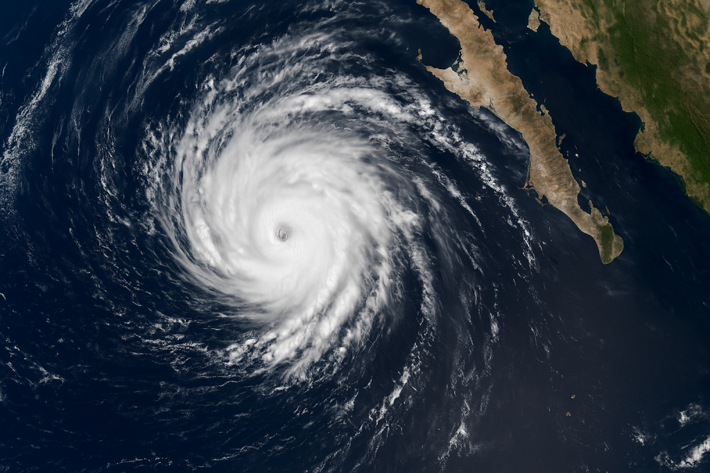
On the first day of this week, Tropical Storm Lorena was upgraded to a Category 1 hurricane and was whirling just off the coast of Mexico’s Baja California peninsula. Lorena already has maximum sustained winds of about 80 miles per hour (130 kilometers per hour), which triggers not just hurricane warnings and tropical storm watches in some areas of Baja California Sur, but also in the tourist hotspot of Los Cabos.
The fact that the storm has escalated to a hurricane in less than 48 hours has sounded many alarms in the region. The civil protection agency in Mexico has been advising its citizens to prepare against a lot of rain, risky surf, and potential evacuations of risk areas along the coastlines.

Threat to Baja California
Lorena will bring 6 to 15 inches of rainfall in certain regions, according to the National Hurricane Center (NHC), posing the threat of flash flooding and mudslides, particularly in rocky areas. Popular tourist spots of the peninsula, including Cabo San Lucas and La Paz, might be exposed to flooded streets, power blackouts, and cancellations.
Local officials are encouraging visitors and residents to hoard supplies, not visit low-lying neighborhoods, and evacuate should they receive orders. Powerful waves and rip currents have already been reported at beaches on the southern end of the peninsula.
U.S. Effects: Flooding may occur in Texas
Although Lorena is not expected to land in the United States, its leftover moisture will blow to the north and hit a frontal boundary in the next few days. This has the potential to trigger heavy precipitation in regions of Arizona, New Mexico, and Texas, forecasters say.
The National Weather Service has issued a Level 1 excessive rainfall warning on a large portion of Texas, warning that localized flash flooding may occur. Some cities like San Antonio, Austin, and Dallas-Fort Worth can experience a wide rainfall of 1-2 inches, and a few areas can get as many as 5 inches.
Meteorologists note that even though the rain will be helpful in the drought-afflicted areas, downpours may overload drainage systems and cause unsafe driving conditions.
Preparedness and Next Steps
In both the United States and Mexico, authorities are encouraging people to pay attention to projections. Baja California tourists are even being encouraged to keep in touch with airlines and hotels because flights will probably be delayed and cancelled once the situation deteriorates.
Emergency management teams in Texas are training on potential flood responses, asking people to avoid roads topped by water and reminding everyone on the lifesaving rule: Turn around, don’t drown.
Conclusion
The unpredictability of the Pacific hurricane season of 2012 is highlighted by Hurricane Lorena which has developed very quickly. With Mexico preparing to face the impacts of landfell and the U.S. monitoring the potential of flooding, the storm is a convincing way to remember how fast it takes the tropical systems to increase in size and extend their impact over a long distance, much further inland.
Q: Where is Hurricane Lorena right now?
A: As of Wednesday morning, Lorena was located southwest of Cabo San Lucas, Mexico, moving northwest with sustained winds of 80 mph.
Q: Will Hurricane Lorena hit the United States?
A: The storm is not expected to make U.S. landfall, but its moisture could bring heavy rainfall to Arizona, New Mexico, and Texas.
Q: What areas of Texas are at risk?
A: Central and southern Texas—including San Antonio, Austin, and Dallas–Fort Worth—may experience localized flooding this weekend.
Check out Our Treading news Category to get news like this


Heya i’m for the primary time here. I came across this board and I to find It really useful & it
helped me out much. I am hoping to present something back and aid others such as you helped me.